Notable points on the panorama, from the left:
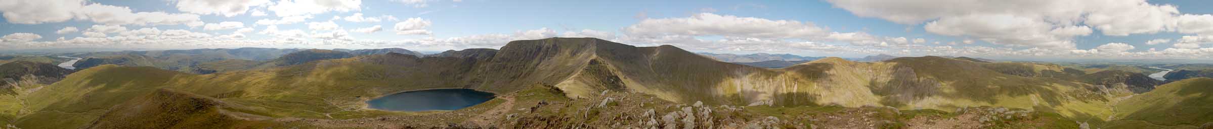
Glenridding Beck lies in the valley below, with Sheffield Pike, Gowbarrow Fell and Little Mell Fell beyond. Ullswater wends its way into the distance with Cross Fell, highest of the Pennines, Great Dun Fell and Little Dun Fell just visible on the horizon. In the crook of Ullswater, in line with Great Dun Fell, is Hallin Fell, then Birk Fell, at the northern end of the bulk of Place Fell, leads the eye to Arthur's Pike beyond. The summit of Birkhouse Moor is closer to us, then the summit of Place Fell in front of Loadpot Hill and on the horizon, Mickle Fell. The High Street range continues from Loadpot via Wether Hill and Red Crag to High Raise. Rest Dodd is closer to the viewer almost blending into the background and the famous Hole-in-the-Wall with it's path to Red Tarn is in the foreground. Selside Pike! and Rampsgill Head appear very close together in the distance before the Straights of Riggindale (with Birks closer) and High Street itself - Gray Crag is just visible in front of it. Hartsop Dodd appears, apparently on its own, in the middle distance then Thornthwaite Crag on the horizon followed by Caudale Moor, Ill Crag and Yoke. St. Sunday Crag shows its bulk on the nearby horizon then Red Screes appears in the distance. Dove Crag and Hart Crag lead to Fairfield just beyond Low Spying How at the start of Striding Edge. Red Tarn nestles in the hollow. Greatrig Man peeks round the side of Fairfield and through the gap one can see to Morecambe Bay. Dollywagon and Nethermost Pikes lie beyond the final section of Striding Edge before the mass of Helvellyn appears with Swirral Edge linking it to Catstye Cam. Further to the right is Helvellyn Lower Man then there's a wonderful view of the northwestern fells through the gap between it and White Side, comprising: High Stile, High Raise (Dale Head in front), Red Pike, Hindscarth, Robinson, Mellbreak, Whiteless Pike, Wandope, Grasmoor, Eel Crag, Whiteside (High Seat in the middle distance), Hopegill Head, Grisedale Pike, Whinlatter and Lord's Seat. Through the gap between White Side and Raise on a clear day one can see the Solway Firth then Dodd, Long Side, Skiddaw, Jenkin Hill and Lonscale Fell. Beyond Raise is Blencathra, and Great Dodd with Stybarrow Dodd just visible in front of it. Souter Fell is the last of the Northern fells visible before the Eden Valley - Rannerside on the slopes of Great Dodd is visible in front of it. Greenside sweeps down from Stybarrow Dodd across the scene, the collapsed mines easily visible. Hart Side can be seen just behind it with Great Mell Fell beyond the lower slopes as they sweep down to Watermillock Common. Little Mell Fell is in the middle distance beyond Sheffield Pike, site of some of the best views of Ullswater. This picture is also available as a larger, 5944 x 458 pixel, 275 kbyte jpeg.
Catstye Cam to Dollywagon Pike - walk details
![]()
![]()
![]()